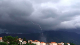
 Great Lakes waterspouts (NOAA file photo of Lake Huron)
Very common over the warm water in September, when water temperatures peak after summer months and cooler air temps start moving in, Great Lakes waterspouts are cropping up early this year because of odd cool weather this July. (We won’t mention possible climate change links here.)
A waterspout is a whirling column of air and water mist. The National Oceanic and Atmospheric Administration informs us that waterspouts fall into two categories: fair-weather and tornadic. Tornadic waterspouts develop downward. They resemble land tornadoes, associated with severe thunderstorms, high winds and seas, large hail, and frequent dangerous lightning. Fair-weather waterspouts develop on the surface of the water and grow upward. Because they form in light wind conditions, they normally move very little.
If a waterspout moves onshore, NOAA’s National Weather Service issues a tornado warning, as some tornadoes from offshore can cause significant damage and injury. According to the NWS, the best way to avoid a waterspout is to move at a 90-degree angle to its apparent movement. The agency advises that you never move closer to investigate a waterspout. Some can be just as dangerous as tornadoes onshore.
This week, an unusual cold air system has been moving in from northwest to southeast, first over Lake Michigan, then Lake Huron, and expected on Lake Erie this morning. In fact, if you live or work along Lake Erie, the International Centre For Waterspout Research is looking for spotters there. (Details here. The ICWR is an independent nongovernmental organization of individuals from around the world who have interests in waterspouts from research, operational, and safety perspectives. Conceived at its 2008 founding as a forum for researchers and meteorologists, the ICWR has now expanded to cover inquiries and contributions from storm chasers, the media, the marine and aviation communities, and private individuals.)
Two years ago, the experimental Great Lakes waterspout model from ICWR began issuing waterspout forecasts for that region of the US.
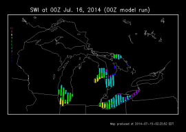
“The experimental Great Lakes waterspout forecast displays values of the Szilagyi Waterspout Index (SWI). [Meteorologist Wade Szilagyi is head of the International Centre for Waterspout Research.] The SWI is derived from the Waterspout Nomogram which uses output from the Canadian GEM model [established 20 years ago]. Values of SWI range from -10 to +10. Waterspouts are likely to occur when SWI ≥ 0…. Increasing values of SWI represent higher potential of waterspout occurrence. Additional consideration of areal coverage of the SWI field is equally important in assessing waterspout potential, as well as surface convergence and enhanced lift.”
 At right is an experimental waterspout forecast model from the International Centre for today, July 16. On the map, shaded areas have a chance of waterspouts, but the green and yellow locations have the greatest chance. This week’s updated maps have shown lower Great Lakes waterspout potential continuing from Sunday until at least Wednesday. SWI waterspout index values have been positive for this period over the area. (See other forecast maps here.) Most of Lake Michigan is still probably too cool for waterspouts, forecasters have said. However, the south shore is around 70 degrees.
 ICWR Great Lakes waterspout observers deployed around Lake Michigan early Tuesday morning (see photo). The first waterspout of the day formed around 8:45 am on the south end of Lake Michigan at South Haven, a very popular summer vacation spot for Chicagoans and others from the region. At Navy Pier in Chicago, Nick Ulivieri spotted a spout forming offshore (between the pier’s twin towers). An hour and a half later, other spotters reported a waterspout over Lake Huron off Goderich, Ontario.
The 5 pm forecast Tuesday showed the chance of waterspouts growing yesterday evening, with the southern end of Lake Michigan and Saginaw Bay (the warmest spot in Lake Huron) registering seven or eight on a scale that goes to 10. The coldest air aloft has overlain Saginaw Bay yesterday evening, overnight, and early this morning. Lake St. Clair was also reported warm enough for waterspouts Tuesday evening into Wednesday morning.
Also: as of Tuesday night, the Live Global Waterspout Watch reported not only the Lake Michigan and Huron waterspouts, but also sightings off the Bahamas, Italy, and Greece. PlanetSave will be watching (sadly, only online)!