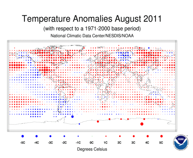
According to America’s National Oceanic and Atmospheric Administration, 2011’s August was the eighth warmest since record keeping began back in 1880 and the period of June to August was the seventh warmest such period as well.
Additionally, the Arctic sea ice extent was the second smallest for an August on record, measuring in at 28% below the average.
All of these records were detailed in the NOAA’s monthly analysis from its National Climatic Data Center which they provide for government, business and community leaders. Below are a summary of the highlights.
Global Temperature Highlights: August
- The combined global land and ocean average surface temperature for August 2011 was the eighth warmest on record at 61.09 F (16.15 C), which is 0.99 F (0.55 C) above the 20th century average of 60.1 F (15.6 C). The margin of error associated with this temperature is +/- 0.16 F (0.09 C).
- Separately, the global land surface temperature was 1.51 F (0.84 C) above the 20th century average of 56.9 F (13.8 C), making this the second warmest August on record. The margin of error is +/- 0.32 F (0.18 C). Warmer-than-average conditions occurred across most of North America and the northern half of South America, southern Greenland, eastern Russia, Mongolia, most of Europe, northern Africa to Southwest Asia, and southern Australia. Cooler-than-average regions included western Russia, Alaska, Chile, Argentina, and Uruguay.
- The August global ocean surface temperature was 0.79 F (0.44 C) above the 20th century average of 61.4 F (16.4 C), making it the 12th warmest August on record. The margin of error is +/- 0.07 F (0.04 C). The warmth was most pronounced across the north central, northwest, and south central Pacific Ocean, the north-central Atlantic, and the Labrador Sea.
- Scotland and Northern Ireland had their coolest average monthly August temperatures since 1993. Scotland was 1.4 F (0.7 C) below its 1971–2000 average of 55.2 F (12.9 C), while Northern Ireland was 1.3 F (0.8 C) below its average temperature of 57.6 F (14.2 C).
- Australia’s August 2011 average maximum temperature was the fifth warmest August in its 62-year period of record. The state of Tasmania had its all-time warmest August maximum and minimum temperatures on record.
Global Temperature Highlights: June – August
- The combined global land and ocean average surface temperature for June – August 2011 was the seventh warmest on record at 61.11 F (16.16 C), which is 1.01 F (0.56 C) above the 20th century average of 60.1 F (15.6 C). The margin of error associated with this temperature is +/- 0.16 F (0.09 C).
- Separately, the global land surface temperature was 1.55 F (0.86 C) above the 20th century average of 56.9 F (13.8 C), which was the third warmest June – August period on record. The margin of error is +/- 0.29 F (0.16 C). Warmer-than-average conditions occurred across Mexico, the eastern two-thirds of the United States and Canada, and most of Europe and Asia. Cooler-than-average regions included southern Alaska, Chile, Argentina, Uruguay, and northern Australia.
- The June – August global ocean surface temperature was 0.81 F (0.45 C) above the 20th century average of 61.5 F (16.4 C), making it the 11th warmest June – August on record. The margin of error is +/- 0.07 F (0.04 C). The warmth was most pronounced across the north central, northwest, and south central Pacific, the equatorial north Atlantic, and the Labrador Sea.
Global Temperature Highlights: Year to Date
- The combined global land and ocean average surface temperature for the January – August period was 0.92 F (0.51 C) above the 20th century average of 56.9 F (13.8 C), making it the 11th warmest such period on record. The margin of error is +/- 0.18 F (0.10 C).
- The January – August worldwide land surface temperature was 1.40 F (0.78 C) above the 20th century average — the seventh warmest such period on record. The margin of error is +/- 0.36 F (0.20 C). The global ocean surface temperature for the year to date was 0.74 F (0.41 C) above the 20th century average and was the 11th warmest January-August period on record. The margin of error is +/-0.07 F (0.04 C).
- Last month, La Niña conditions returned. According to NOAA’s Climate Prediction Center, La Niña is expected to gradually strengthen and continue into the Northern Hemisphere winter 2011/12.
Polar Sea Ice and Precipitation Highlights
- The average Arctic sea ice extent during August was 28 percent below average, ranking as the second smallest August extent since satellite records began in 1979. The extent was 830,000 square miles (2.15 million square kilometers) below average and 61,800 square miles (160,000 square kilometers) above the record low August extent set in 2007.
- According to model analysis by the University of Washington’s Polar Science Center, Arctic sea ice volume, which depends on both ice thickness and extent, reached a record low of 1,026 cubic miles (4,275 cubic kilometers) on August 31, 2011, breaking the previous lowest volume set on September 15, 2010. The average August 2011 volume was 1,200 cubic miles (5,000 cubic kilometers). This value is 62 percent lower than the 1979–2010 average and 72 percent lower than the maximum in 1979.
- Conversely, the August 2011 Antarctic sea ice extent was 0.08 percent above the 1979–2000 average and was the 14th smallest (20th largest) August extent since records began in 1979.
- The June – August 2011 (Southern Hemisphere winter) was Australia’s first drier-than-normal season since September – November 2009 and was 12 percent below the 1971–2000 average.
Source: NOAA


